Monday, July 16, 2007

Day 13

The long drive home

We got a little ways into Nevada last night. Found a dirt road in the desert and threw our sleeping bags on the ground for a few hours sleep. It rained during the night, but not hard.

our sleeping area last night. In the distance is the Ruby Mountain Range. A few people have flown this 60 mile range. It looks great.

I got home at 5pm. The odometer on my car shows nearly 2100 miles. I can't wait to do it again.

Sunday, July 15, 2007

Day 12

5th Day of the comp

The forecast today was not looking good, and our morning weather report had indicated significant development starting early. Route 3 was called as it seemed to be the best shot to get out ahead of the weather.

All I wanted to do today was launch as early as I could. The weather was approaching fast, and I did not want to get stuck on the mountain. I figured there was a good chance I would sink out since I was launching so early, but that was better than not flying at all.

I had a short flight down to the LZ, but was glad I had gotten off the hill at all. A bit of rain fell as I broke down my glider, and the rest of the pilots flew down to the bail out as well.

Setting up to land with a gloomy sky

Ben doing a bit of aerobatics before landing


The weather report had been right about the morning, but was wrong about the afternoon. By 3pm the sky was clear and conditions looked great. The few pilots who had waited it out got flights of 40-60 miles....

BBQ and award ceremony tonight, and then we are hitting the road for the long drive back. The plan is to get a few hours into the drive tonight, and then make the rest of the haul tomorrow.

My total score for the meet was 15 points. Not too good, but this place is big air and there is a lot to learn. Next year I'll be back and ready.

Saturday, July 14, 2007

Day 11

4th day of the comp.

Today was a frustrating day. Route 3 was called again. I was excited to go over the back, but the overdevelopment from the west and north was approaching fast. I launched later than I should have, and started to climb. The wind was pushing the thermals east and kept drifting me close to the mountain. It was also crowded in the air and I was sharing thermals with multiple gliders. I got chased out of a few good thermals when another pilot would break the "right of way" rules for thermalling and force me to avoid him.

I was frustrated by the crowds, and having a difficult time getting over 10,500'. I wanted at least 14,000' to jump over the back and avoid the rotor (bad, turbulent air that is found on the lee side of big objects like mountains). Eventually I decided the approaching storm was too close and I was out of time. I abandoned my thermal and dove my glider fast down to the LZ.

Flying out to land, with a big storm to the north.

No one got far today. The development was worse in the next valley. Only one day left.

Friday, July 13, 2007

Day 10

Day 3 of the competition.

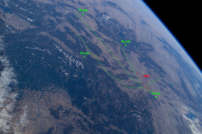
Route 1 was called today. This is many people's favorite route as it goes North up the mountain range, through some great geography. The route goes through Mackay, up to Chalis, and on to May and finally up to Salmon for 100 miles.

I didn't get anywhere near 100 miles. I ended the day with a modest 13 mile flight, but it was a ton of fun.

The first task is to get high. I couldn't find a thermal close to the hill, but I kept my eye on a glider that had gone out to land. Just over the LZ he hooked a big one and was climbing fast. I pulled on some vg, and darted over to him. 3 of us climbed for a long time in that thermal until we were well above the peek. My max altitude was 13,000 feet.

There was a bit of a northern component to the wind (meaning it was FROM the north), so it was slow going. Thermals would drift me south and then I would have to make up ground gliding north, until I had to climb in a thermal again which would drift me south.

The first big hurdle is Rams Horn Canyon. Rams Horn is a large gap in the mountain range. A powerful venturi sets up here as the wind gets funneled through the gap. It can be very dangerous to get low in such a gap, and more than one pilot has found himself trapped in very strong winds in Rams Horn after letting himself get low in it. My plan was to give it lots of height, and to pass out in front of it.


The gap in the mountain above my head is Rams Horn. Further North, where the range bends to the West is Elbow Canyon (another tricky spot to pass, with a potential venturi)


Once passed Rams Horn I continued to work my way North. Thermalling up and going on glide. At the edge of Elbow Canyon, I began to get low. So low in fact, that I was setting up to land. 300 feet off the ground I managed to find a small thermal that eventually took me back up to 12,000'

The un-irrigated corner of the pitch to the left of my head is where I got very low and was planning on landing. Above and to the right is Elbow Canyon

Back in the game! Thermalling up at 12,000'!

From 12,000' I decided to cross Elbow Canyon. It was a long glide, but I wanted to make it before an approaching cloud cast it's shadow on the hillside I was flying (The shadow can stop the ground from heating, and shut down the thermals). My hope was that if I stayed over the edge of the shadow I would find some lift as I made the crossing.

Starting to cross the pass, with a big shadow approaching.

My plan did not work. I made it across the pass, but I was low and the foothills I was sure would provide some lift did not. I hoped for another low save, but this one did not come and I found myself setting up for a landing. I picked a clear spot near a road, scanned for power lines and fences, and made my approach.

In my left hand, you can see a streamer I dropped to show me the wind direction on the ground.

I had a good landing. 13 miles was not as far as I had wanted, but it was a tough day and I was very happy with the flight.

My glider with Kind Mountain off in the distance.

Chris and Wendy picked me up, and we set off to chase our good friend and hang gliding legend KM. KM flew over my head at 15,000 feet while I was breaking down my glider, and continued on for another 31 miles before landing to avoid an approaching storm.

We drove back to town through rain and gust fronts and got ready for another day.

Thursday, July 12, 2007

Day 9

Second day of the comp.

Route 3 was called again today because there was a good chance of thunderstorms developing. Route 3 is the safest route in this type of weather because it gets away from the mountain ranges and out into the flats where less nasty weather develops, and it is easier to avoid.

However, after setting up, suiting up, and getting ready to launch, I decided to set my glider back down and pack up. Thunder clouds were developing to the West and North, and I did not want to regret being in the air. Powerful gust fronts can develop when a thunder cloud suddenly drops it's moisture, and the unwary pilot can find himself caught in 40-70mph winds.

It was tough to break down and skip a day of the comp, but it was the right decision. The rest of the weeks is forecast for better weather, and I still have 3 days to compete.

Wednesday, July 11, 2007

Day 8

First day of the competition.

Things get started at 9am with a pilots meeting. We go over weather mostly, and discuss a few rules.

Shortly after, we head up to launch, set up our gliders, and wait for the route to be called. There are 4 potential routes that can be called depending on weahter.

Route 3 was called, and people started to launch. I got in the air after waiting in a long launch line, and slowly climbed. I was uneasy about some weather that was developing to the West, so eventually I went and landed in the bailout LZ.


#5 in line to launch. It was 90 degrees, and we are dressed extremely warm for the sub-zero temperatures and 25mph winds we will experience when we get high.


In the air, at King Mountain (looking West towards Moore)

Chris was there in the bailout LZ also and we sat watching others climb out (soar up over the peak) and head over the back of the mountain on course.

Heather went on the wrong route, but still managed to get back on track after a 20 mile detour.

Total points for the day..... 1

pics to follow

Tuesday, July 10, 2007

Day 7

Laundry and getting ready for the comp. The meet starts tomorrow. No flying today.

Monday, July 9, 2007

Day 6

Today was a traveling day. We drove 550 miles to Moore, ID. The drive was great, going through desert, lakes, and lava fields.


Lake Albert, about 30 miles outside of Lakeview

Sunday, July 8, 2007

Day 5

The Forcast was for NE winds, which pretty much shuts down Lakeview. So we headed 50 miles North East to a site called Hadley's Butte, which has a NE facing launch. It was a fun new site to fly, but there was little lift, so we did not go far and our flight were short.


Summer Lake, a salt lake, in the background


The landscape out here was beautiful. This is the field I landed in, with the lake in the background

Saturday, July 7, 2007

Day 4

Today was a great day. The best flight of my life. I flew for 2 hours and 42 minutes. I flew 23 miles, and got to 12,300'.
We launched from a site called Sugar, which is about 25 miles south of Lakeview, OR. I was the second in the air, and struggled for about an hour to find a thermal that would get me high enough to jump across Fandango Pass and start heading north. I finally found the thermal that would do it. It took me to 10,500', and I said goodbye to the launch and LZ that I am familiar with and ventured north into the unknown.

It is truelly thrilling to be flying over such varying terrain, not knowing where, or when, you are going to land. Looking at the sky, and the mountains, and figuring out where you will find the next thermal that will get you a bit further down the range.
At 12,000 feet and heading north!

A few miles south of Lakeview, I ran out of air (couldn't find any more lift) and started looking for an LZ. I found a field that looked nice with no power lines, and an open gate. I landed gently and my friends were there within minutes to pick me up and share in the excitment.

Brian by his LZ. Above my head, and slightly to the right, way off in the distance, is the hill I launched from almost 3 hours earlier.

Tomorrow we go back to Sugar and hope to get higher and go farther.

Friday, July 6, 2007

Day 3

Today we drove to Lakeview Oregon. It is a great town and the whole community loves that hang gliders come here to fly. They hold a fly-in festival the weekend of the 4th usually. Driving in to town there are big signs saying "Welcom Hang Gliders", and all the land owners are so friendly and really enjoy having us be here. It is a change from a lot of places where you often have to worry when you land in a field, if the land owner is going to be happy or mad.

We went to a launch called Black Cap just above the town, but did not fly today. Conditions were overdeveloped, and it was not safe to fly.

Thursday, July 5, 2007

Day 2

Today we got up early to go and try a flight off of Burney Mountain (elevation 7,800). It's a dome shaped mountain West of Hat Creek. It blows out early, so we were up there by 8:30, and in the air by 9:30am.


Looking NorthWest towards Mt Shasta (we launch to the South)


The launch - It looks worse than it is. You are in the air before you get to the big nasty rocks....

Launch was nice and smooth, and so was the air. As nice as that sounds, that means there was no lift to be had. So we glided out to the LZ for a short and sweat 10 minute flight.

This LZ is rather tricky. There are a lot of trees so you need to pick your aproach carefully. No problems were had, though my landing was not so gracefull....

The LZ with Burney Mt in the background.

This evening we went back to Hat Creek. Conditions where very turbulent at first, util I found an area of lift that took me way above all the nasty stuff. I boated around for about an hour at 7,000'. Conditions to the East of us started to look bad. The clouds were dark and spreading. Chris and I decided to land in case the clouds turned into to thunder storms. Shortly after landing we heard thunder and knew we had made the right choice.

The clouds made for a spectacular sunset.


Tomorrow we head to Lakeview Oregon where the XC flying will begin!

Wednesday, July 4, 2007

Day 1

After working 15 hours the day before, I was finally ready for my trip. All packed up and ready to go, I started the 5 hour drive from Redwood City to Burney, CA. This is the first stop on the trip and I’ll be flying at a place called Hat Creek for 2 days.


My home in Burney at the Green Gables Inn. Friendly, clean, and cheap.


Hat Creek is a great site. The wind pushes the warm air up the volcanic ridge producing reliable, smooth lift. You don’t typically fly XC from here. You just boat around until sunset. Hat Creek Rim with Mt Lassen off in the distance, and Chris off in front of me


I had a great, enjoyable flight. Lift topped out about 1500’ over launch. Got to watch the sunset from the air. The only downside, is that it is HOT here!

Sunset from 5,300' with Mt Shasta in the background

Beer, the first thing you need after a long, hot flight. (Brian, Chris & Wendy in the LZ)

Flight time: 2:30 (2 hours, 30 minutes)

Tuesday, July 3, 2007

The Trip

Here's the plan. A 2 week hang gliding vacation. I will be traveling with my flying buddy Chris and his wife Wendy. We will travel through Northern California, Oregon, and finally to King Mountain Idaho flying the along the way. Our final destination is King Mountain, Idaho, where I will compete in the King Mountain Hang Gliding Championship.

The Championships is and XC Competition (www.flykingmountain.com). It is the best 3 out of 5 days. You get one point per mile flown. I believe the site record is around 200 miles!

I hope to keep at least a semi-regular update of my trip on this blog.